Apollo 12 Flown to the Moon Oribital Charts
Taken from the Apollo 12 CSM Orbital Photo Chart "B"
From the personal collection of Astronaut Dick Gordon
These maps are now all sold but, but we still have some Apollo 12 Flown Landmark Maps
These sections of lunar orbital chart are taken from the Apollo XII Command and Service Module Orbital Photo Chart "B". Which was flown and used in Lunar Orbit by the Apollo 12 Crew during their mission in November 1969.
They show late orbit ground tracks of revolutions 39, 42 and 45 over the surface of the moon. They also depict related features such as Control Points, Ground Tracks, Initial Point, Landing Sites, Surveyor, Terminators, and much more.
Compiled from nearly 4000 photographs taken from lunar orbit by the Ranger and the Lunar Orbiter, the Orbital Monitor Chart "B" was one of only two charts that were used on the Apollo 12 mission. The Ranger and Lunar Orbiter programs were a series of unmanned space missions in the 1960s whose objective was to obtain close-up images of the lunar surface to create a comprehensive photo-map for use during the Apollo Moon landings by the crew as a guide for Lunar Navigation and to identify specific landmarks.
Each Map comes with a Dick Gordon hand signed COA
These orbital chart sections differ from our other Apollo 12 Flown Landmark Maps in that these are sections cut from a larger map, printed on very thin paper, whereas the Landmark maps are individual pages originally housed in a ring binder and printed on photographic paper.
Please indicate which number map you are interested in
Apollo 12 - Flown Map Plate #10-11
Measures 10.5 x 12.3 inches on the left going down to 10.5 x 11.5 on the right. This is one of the largest maps we have offered and is actually one and a half continuous maps (10 and 11) not taped together but does have a foldDick has added in his inscription "Targets Of Opportunity on revs 39-45"
Comes with Dick Gordon hand signed COA
SOLD
Email us If You Want To Buy This Map
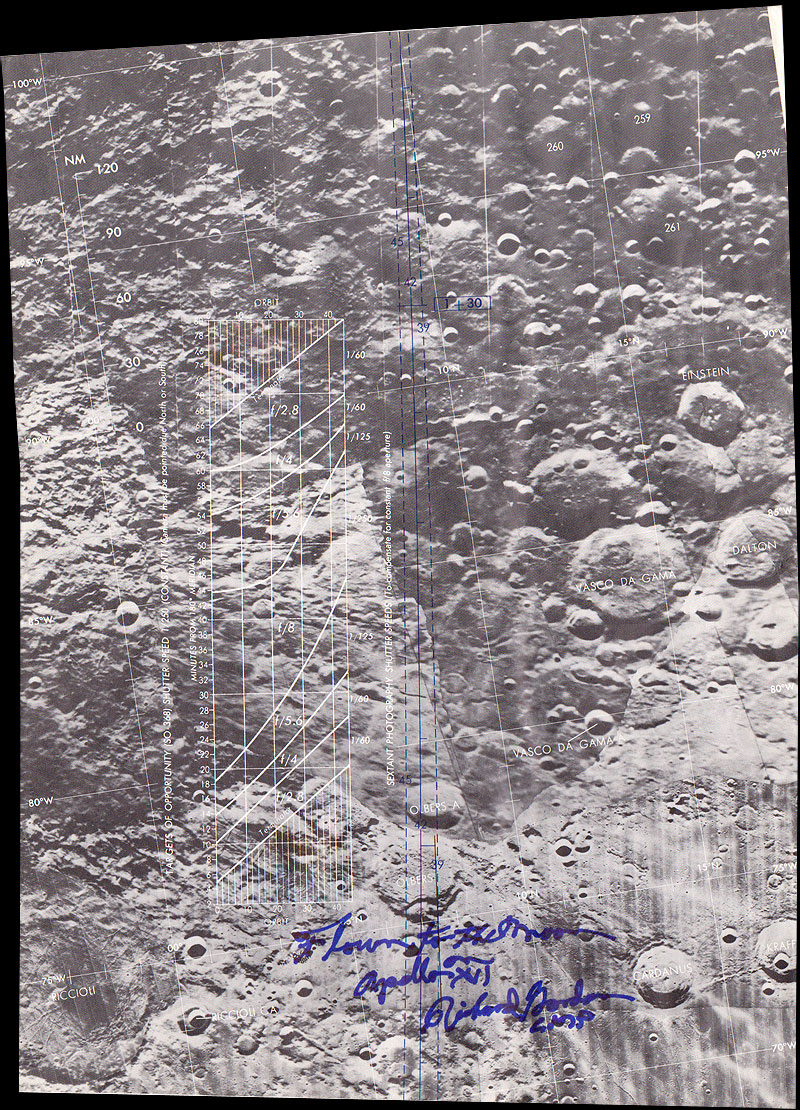
Apollo 12 - Flown Map Plate #18-20
Measures 10.5 wide by 14 inches on the left going up to 14.8 on the right. This is one of the largest maps we have offered and is actually two and a half continuous maps (18,19 and 20) with a foldThis Map shows an entire Sextant Photography Exposure Chart, an 8 inch high box containing f stops and shutter speed settings depending on which orbit and how many minutes from the Meridian the photo would be captured from.
Comes with Dick Gordon hand signed COA
SOLD
Email us If You Want To Buy This Map
Apollo 12 - Flown Map Plate #21
Measures 10.5 x 6.9 inches on the left going up to 10.5 x 7.3 on the right.Includes a Scale in Nautical Miles
Comes with Dick Gordon hand signed COA
SOLD
Email us If You Want To Buy This Map
Apollo 12 - Flown Map Plate #12
Measures 10.5 x 7.3 inches on the left going down to 10.5 x 6.9 on the right.Dick has added in his inscription,"DE1 Target For Landmark Tracking"
Comes with Dick Gordon hand signed COA
Price: SOLD
Email us If You Want To Buy This Map
Apollo 12 - Flown Map Plate #15
Measures 10.5 x 7.25 inchesThis Map actually shows 'The Ocean Of Storms' close to where Apollo 12 landed
Comes with Dick Gordon hand signed COA
Price: SOLD
Email us If You Want To Buy This Map
Apollo 12 - Flown Map Plate #16-17
Measures 10.5 x 14.5. This is the largest map we have offered and is actually two continuous maps (16 and 17) lower section is taped to the upper section, (this is how all the maps were originally during the flight) plus has a fold in the middle.The bottom of the map also shows 'The Ocean Of Storms' and the position of Surveyor 1 plus alternative landing sites 5 and 6R for Apollo 12
Dick has added in his inscription "Photo Targets Of Opportunity on revs 42"
Comes with Dick Gordon hand signed COA
Price: SOLD
Email us If You Want To Buy This Map
Apollo 12 - Flown Map Plate #2
Measures 10.5 x 7.25 inches on the left going up to 10.5 x 7.5 on the right.Dick has added in his inscription,"Photo Targets, Lunar Farside Revs 39-45"
Comes with Dick Gordon hand signed COA
Price: SOLD
Email us If You Want To Buy This Map
Apollo 12 - Flown Map Plate #3
Measures 10.5 x 7.25 inchesDick has added in his inscription,"Lunar Farside"
Comes with Dick Gordon hand signed COA
Price SOLD
Email us If You Want To Buy This Map
Apollo 12 - Flown Map Plate #22
Measures 10.5 x 6.9 inches on the left going up to 10.5 x 7.3 on the right.Includes a Scale in Nautical Miles
Comes with Dick Gordon hand signed COA
Price SOLD
Email us If You Want To Buy This Map
Apollo 12 - Flown Map Plate #23
Measures 10.5 x 6.8 inches on the left going up to 10.5 x 7.1 on the right.Bottom section is taped to the top section (as the whole map was originally during the flight)
Comes with Dick Gordon hand signed COA
Price: SOLD
Email us If You Want To Buy This Map
Apollo 12 - Flown Map Plate #24
Measures 10.5 x 6.5 inches on the left going up to 10.5 x 7.2 on the right.This map contains a very interesting addition, the legend for the whole overall map.
Comes with Dick Gordon hand signed COA
Price: SOLD
Email us If You Want To Buy This Map
Apollo 12 - Flown Map Plate #25
Measures 10.5 x 6.5 inches on the left going up to 10.5 x 7.2 on the right.Dick has added "Lunar Farside" to the inscription
Comes with Dick Gordon hand signed COA
Price: SOLD
Email us If You Want To Buy This Map
Apollo 12 - Flown Map Plate #4
Measures 10.4 x 7.25 inches, 2 pieces joined together by NASA using tape on rear sidePrice: SOLD
Email us If You Want To Buy This Map
Apollo 12 - Flown Map Plate #5
Measures 10.4 x 7.25 inches on left sloping down to 7 inches on rightPrice: Sold
Email us If You Want To Buy This Map
Apollo 12 - Flown Map Plate #6
Measures 10.4 x 7 inches on left sloping up to 7.25 inches on right - signed upside down hence low pricePrice: SOLD
Email us If You Want To Buy This Map
Apollo 12 - Flown Map Plate #7
Measures 10.4 x 7.5 inches on left sloping down to 7 inches on rightPrice: SOLD
Email us If You Want To Buy This Map
Apollo 12 - Flown Map Plate #8
Measures 10.4 x 7.5 inches on left sloping down to 6.5 inches on rightPrice: SOLD
Email us If You Want To Buy This Map
Apollo 12 - Flown Map Plate #9
Measures 10.4 x 9.5 inches, the largest map plate we have, has a fold along the top quarterPrice: SOLD
Email us If You Want To Buy This Map
Apollo 12 - Flown Map Plate #13
Measures 10.4 x 7.4 inches on left sloping down to 7.1 inches on rightPrice: SOLD
Email us If You Want To Buy This Map
Apollo 12 - Flown Map Plate #14
Measures 10.4 x 7.3 inches on left sloping down to 7.2 inches on rightPrice: SOLD
Email us If You Want To Buy This Map
To be notified of future items like this one Join Our Mailing List
See our other Flown To The Moon Items
Contact Us
All design and images � moonpans.com